The new GPSMAP 1042xsv and 1242xsv are a great solution for those boaters who prefer a full button or keyed unit, but don't want to lose out on the technology that the touch screen displays have to offer. Available in a 10" and 12" screen size these units are packed with everything you need to make it to you destination. It doesn't matter if your just going for a cruise or after that trophy fish this unit can get you there. **Note, the 1242XSV is also offered in a Touch Screen version.
Sonar:
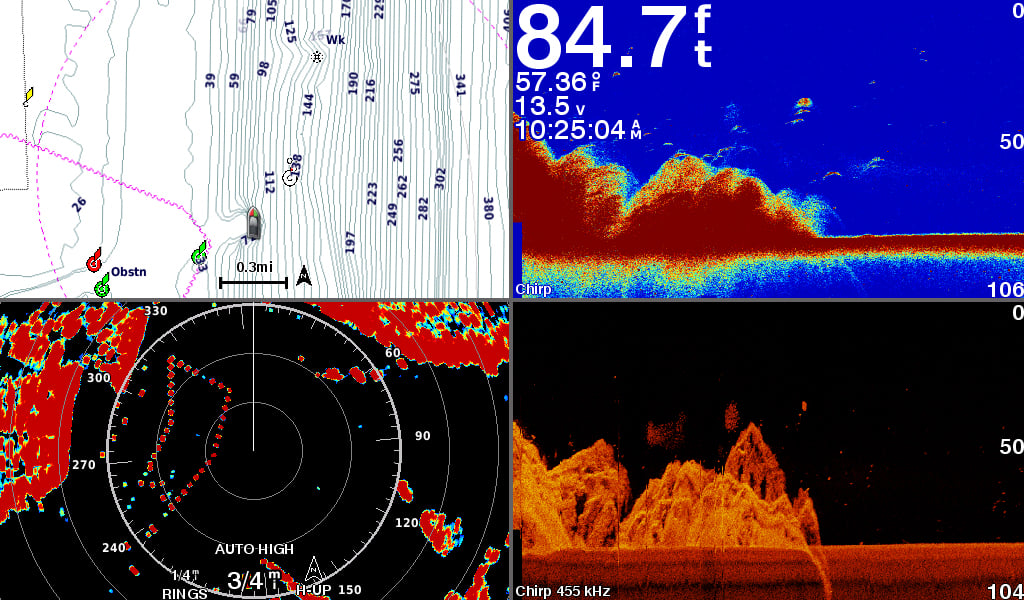
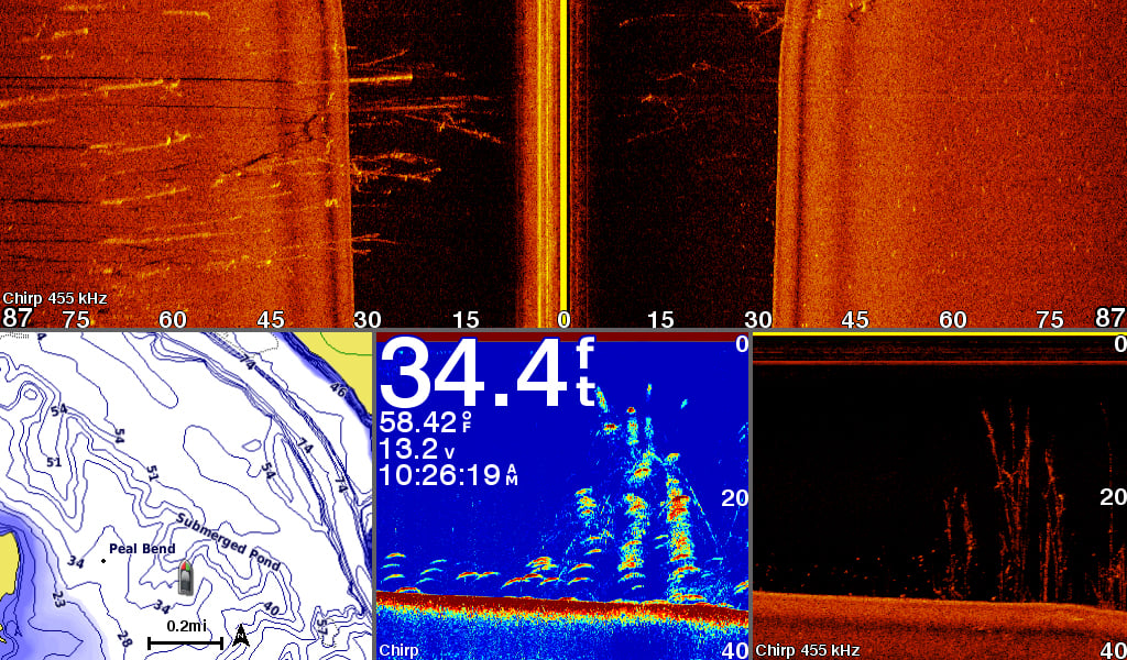
The 1kw CHIRP sonar is a great tool for fishermen near and offshore. In addition to this 1kw built in sounder this unit also comes ready for your ClearVu and SideVu transducer. If you thought that was all then you'll be pleased to know that we can also pug in our Panoptix transducer and any of Garmin's premium sounder modules for an even wider selection of transducers. Although this unit does not include a transducer in the box it is plug and play ready for that Garmin transducer that fits your application specifically.
Charting:
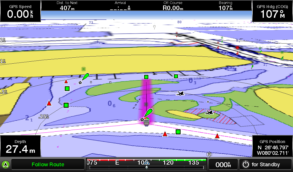
These units will come with built in lake and bluewater charts. Its preloaded with LakeVu and Bluechart G2 charting for coverage almost anywhere in or around the US. This will include 17000+ lakes, rivers, and reservoirs along with tidal stations and plenty of coverage offshore. If your seeking the highest level of chart detail for your area then of course there is always the option to upgrade to the Lakevu Ultra HD or G2 Vision card to get the best possible coverage. If you run your vessel in an area where coverage may not be as detailed or if your looking to see the little bump and dips in contour then we also have the ability to use Garmin's QuickDraw software to make our own charts with up to 1 foot contours. Once we have all the Quickdraw data we need we have the option to share this data with out friends and the rest of the fishing community.
Networking:
With the built in NMEA2000 and NMEA0183 connectivity we can share NMEA data to other units and connect to some of the best sensors and accessories available. There is also built in Ethernet connectivity as well. This Ethernet allows us to us some great devices such as radar, sounder modules, IP cameras, and Panoptix transducers. With these awesome devices we can also use the Ethernet to share our devices to other Garmin compatible units. This includes sharing Satellite weather and radio along with sonar, VHF, and pretty much any other Garmin device you can connect to these units.
WiFi and ANT:
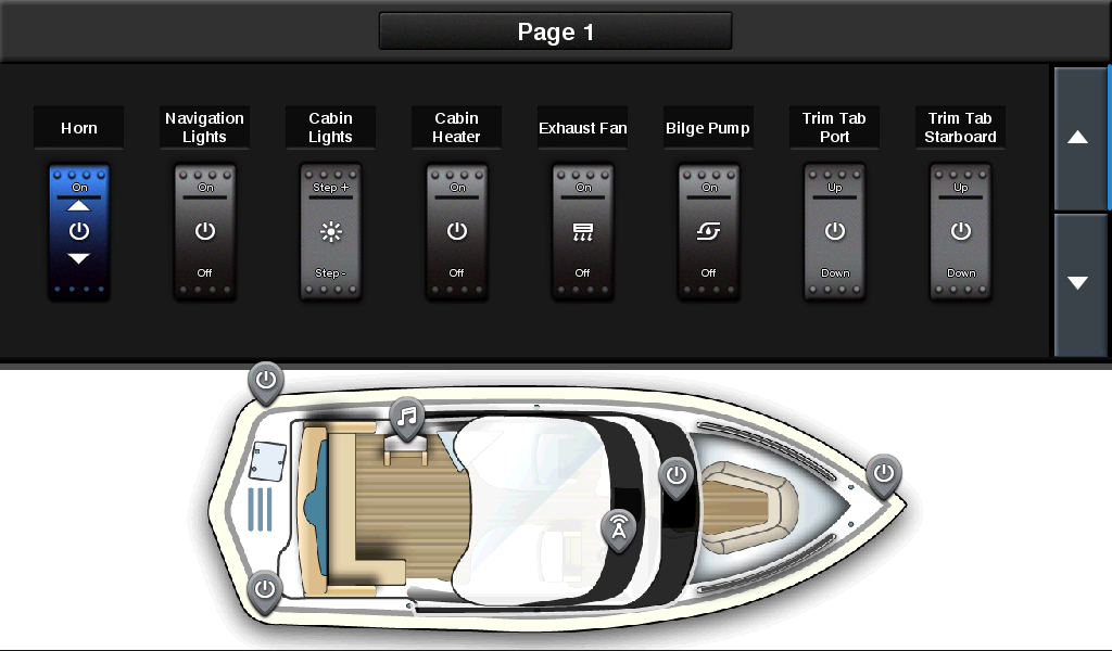
With Gamins built in WiFi the option to connect your personal devices such as tablets, Ipads, and Iphones is now available. These devices have the ability to run BlueChart Mobile and the Garmin Helm App allowing us to upload charting data and routes as well as controlling the MFD through and device with the Garmin Helm App installed. ANT connectivity allows us to connect to Quatix watches Gwind Wireless wind sensors, and wireless remotes.
Antenna:
These units will come with a built in 10Hz GPS antenna that will refreshes 10 times a second and allows up to 5000 waypoints to be stored and navigated to at any given time. This refresh rate lets us pin point locations and drop a waypoint on them with precise accuracy.
Images of Rear to Show Ports
1242XSV (1242 is the same except no Orange Sonar port)
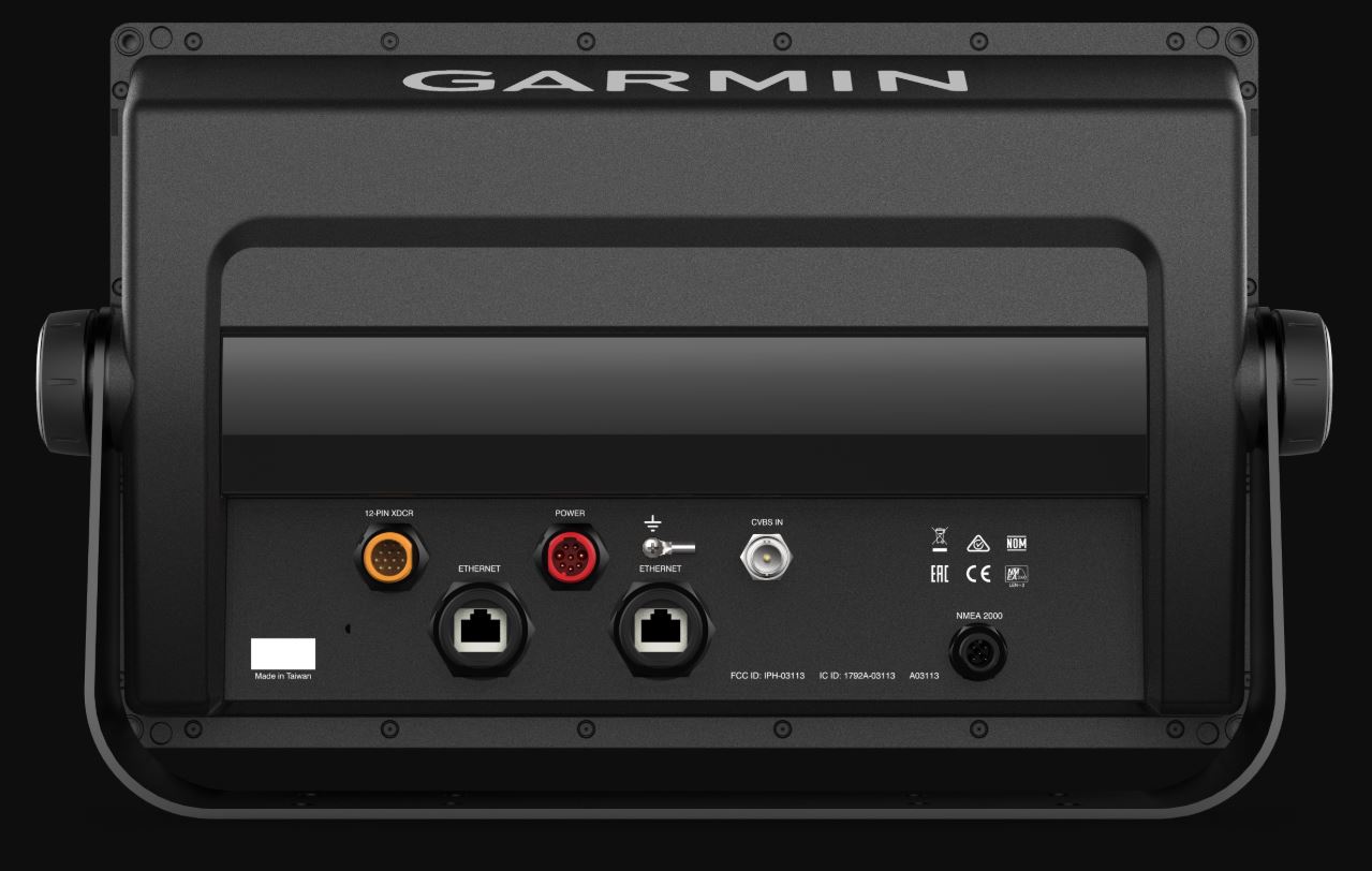
1042XSV (Note: 1042 is the same except no Orange Sonar port)

Specifications- 1242xsv:
| Performance and Physical | |
| Dimensions | 14.1" x 8.9" x 2.7" (35.8 x 22.6 x 6.9 cm) |
| Display size | 10.3" x 6.4" (26.2 x 16.3 cm) |
| Display resolution | 1280 x 800 |
| Display type | WXGA display |
| Weight | 5.2 lbs |
| Water rating | IPX7 |
| Antenna | Internal or external over NMEA 2000 |
| NMEA 2000® compatible | Yes |
| NMEA 0183 compatible | Yes |
| SiriusXM™ Weather & Radio compatible | Yes |
| Power consumption | Max power usage at 10 Vdc: 34.8 W Typical current draw at 12 Vdc: 2.2 A Max current draw at 12 Vdc: 2.9 A |
| Mounting options | Bail or flush |
| Maps and Memory | |
| Preloaded maps | BlueChart® g2 (coastal maps) and LakeVü HD (inland maps) |
| Accepts data card | 2 SD™ cards |
| Waypoints | 5,000 |
| Routes | 100 |
| Track log | 50,000 points; 50 saved tracks |
| Chartplotter Features | |
| Garmin Radar compatible | Yes |
| Garmin Sonar compatible | Yes (with external black box, sold separately) |
| Wireless remote compatible | Yes |
| Supports AIS (tracks target ships position) | Yes |
| Supports DSC (displays position data from DSC-capable VHF radio) | Yes |
| Tide tables | Yes |
| Garmin Meteor Audio System compatible | Yes |
| Supports Fusion Lync compatible marine radios | Yes |
| GSD™ Black Box sonar support | Yes |
| GCV™ Black Box sonar support | Yes |
| BlueChart® Mobile (planning) compatible | Yes |
| Garmin Helm compatible | Yes |
| GRID™ (Garmin Remote Input Device) compatible | Yes |
| Connections | |
| Transducer | 1 - 12 pin |
| NMEA 0183 input ports | 1 |
| NMEA 0183 output ports | 1 |
| Video input ports | 1 BNC |
| Video output ports | None |
| Wireless connectivity | Yes |
| Garmin Marine Network™ ports | 2 |
| Sonar Features and Specifications | |
| CHIRP sonar technology | Yes (Built-in) |
| ClearVü | Yes with CHIRP (built-in) |
| SideVü | Yes with CHIRP (built-in) |
| Dual-frequency (50/200 kHz) sonar capable | Yes |
| Dual-beam (77/200 kHz) sonar capable | Yes |
| Frequencies supported | Traditional: 50/77/83/200 kHz CHIRP (low, medium, high) ClearVü/SideVü (260/455/800 kHz) (dependent on transducer) |
| Transmit power | 1 kW traditional; 1 kW CHIRP |
| Maximum depth | 5,000 ft at 1kW (depth capacity is dependent on water bottom type and other water conditions) |
| Bottom lock (shows return from the bottom up) | Yes |
| Water temperature log and graph | Yes |
| Sonar recording | Yes |
| Sonar history rewind | Yes |
Specifications- 1042xsv:
| Performance and Physical | |
| Dimensions | 12.5" x 7.3" x 2.7" (318 x 185 x 69 cm) |
| Display size | 8.8" x 4.9" (224 x 125 cm) |
| Display resolution | 1024 x 600 |
| Display type | WSVGA display |
| Weight | 4.1lbs |
| Water rating | IPX7 |
| Antenna | Internal or external over NMEA 2000 |
| NMEA 2000® compatible | Yes |
| NMEA 0183 compatible | Yes |
| SiriusXM™ Weather & Radio compatible | Yes |
| Power consumption | Max power usage at 10 Vdc: 32.4 W Typical current draw at 12 Vdc: 1.9 A Max current draw at 12 Vdc: 2.7 A |
| Mounting options | Bail or flush |
| Maps and Memory | |
| Preloaded maps | BlueChart® g2 (coastal maps) and LakeVü HD (inland maps) |
| Accepts data card | 2 SD™ cards |
| Waypoints | 5,000 |
| Routes | 100 |
| Track log | 50,000 points; 50 saved tracks |
| Chartplotter Features | |
| Garmin Radar compatible | Yes |
| Garmin Sonar compatible | Yes (with external black box, sold separately) |
| Garmin SmartMode compatible (customizable monitor presets) | Yes |
| Supports AIS (tracks target ships position) | Yes |
| Supports DSC (displays position data from DSC-capable VHF radio) | Yes |
| Tide tables | Yes |
| Garmin Meteor Audio System compatible | Yes |
| Supports Fusion Lync compatible marine radios | Yes |
| GSD™ Black Box sonar support | Yes |
| GCV™ Black Box sonar support | Yes |
| BlueChart® Mobile (planning) compatible | Yes |
| Garmin Helm compatible | Yes |
| GRID™ (Garmin Remote Input Device) compatible | Yes |
| Wireless remote compatible | Yes |
| Connections | |
| NMEA 0183 input ports | 1 |
| NMEA 0183 output ports | 1 |
| Video input ports | 1 BNC |
| Video output ports | None |
| Wireless connectivity | Yes |
| Garmin Marine Network™ ports | 2 |
| Sonar Features and Specifications | |
| CHIRP sonar technology | Yes (Built-in) |
| ClearVü | Yes with CHIRP (built-in) |
| SideVü | Yes with CHIRP (built-in) |
| Dual-frequency (50/200 kHz) sonar capable | Yes |
| Dual-beam (77/200 kHz) sonar capable | Yes |
| Frequencies supported | Traditional: 50/77/83/200 kHz CHIRP (low, medium, high) ClearVü/SideVü (260/455/800 kHz) (dependent on transducer) |
| Transmit power | 1 kW traditional; 1 kW CHIRP |
| Maximum depth | 5,000 ft at 1kW (depth capacity is dependent on water bottom type and other water conditions) |
| Bottom lock (shows return from the bottom up) | Yes |
| Water temperature log and graph | Yes |
| Sonar recording | Yes |
| Sonar history rewind | Yes |
| Transducer port | 12-pin |
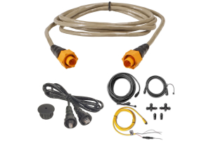
What's in the Box:
- GPSMAP Unit
- Power/data cable
- NMEA 2000 T-connector
- NMEA 2000 drop cable (2 m)
- Bail mount kit with knobs
- Flush mount kit with gasket
- Protective cover
- Trim piece snap covers
- Documentation
- 8-pin transducer to 12-pin sounder adapter cable